Las Tablas, Panama latitude longitude
Decimal latitude and longitude coordinates for Las Tablas (Panama): 7.76667, -80.28333
More about Las Tablas Lat-Long position
Las Tablas is located in Panama country, in Central America continent (or region) [*transcontinental]. DMS latitude longitude coordinates for Las Tablas are: 7°46'0.01"N, 80°16'59.99"W.
• Latitude position:
Equator ⇐ 864km (537mi) ⇐ Las Tablas ⇒ 9143km (5681mi) ⇒ North pole.
• Longitude position:
Las Tablas ⇐ 8828km (5486mi) ⇐ Prime meridian. GMT: -5h.
• Local time in Las Tablas: Sunday 5:46 pm, July 26, 2026. [*time info]

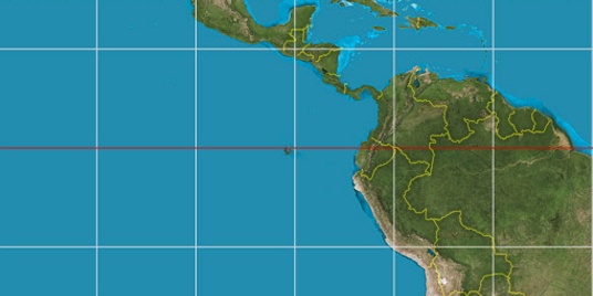

Step for grid lines is 15°. On second map 15° latitude and -75° longitude line is numbered. Map pointer shows the 7.77, -80.28 lat-long coordinates.
[*time info] Shown time is in moment when this page is generated. For more accurate time in Las Tablas visit timein.org (new window).
[*transcontinental] Some countries are spanning more than one continent. Shown continent is same for all cities in this country, but sometimes city is not in this region. You can see the real position on map.
© 2015 - LatitudeLongitude.org Terms of use - programmed by Igi